Kootenay Lake level monitoring
The level of Kootenay Lake is vital to operating our four hydroelectric dams on the Kootenay River. We monitor the lake levels throughout the year, which are governed by the 1938 International Joint Commission order on Kootenay Lake. The International Joint Commission administers the Boundary Water Treaty of 1909 between Canada and the United States, which provides regulations and resolves disputes concerning waters that flow along or across the international border, like the Kootenay Lake watershed.
Updates about lake level changes
You can view current Kootenay Lake levels online or sign up for notifications about large or unusual fluctuations in lake levels. When we anticipate a significant or rapid fluctuation of the lake level, we will make every effort to inform customers who’ve asked to be notified by email or automated phone call.
Why do we monitor Kootenay Lake levels?
Kootenay Lake is part of a watershed that flows across the international border with the United States, and is governed by the International Joint Commission and the 1938 order that provides the parameters for Kootenay Lake elevations throughout the year.
The lake is subject to large natural inflows of water and fluctuations throughout the year and affects the operations of several hydroelectric generating facilities, including four dams operated by FortisBC on the Kootenay River, the Duncan Dam operated by BC Hydro and the Libby Dam operated by the US Army Corps of Engineers.
The International Joint Commission is a bi-national body with three members appointed by each country. It administers the Boundary Water Treaty of 1909 to provide regulations and resolve disputes concerning waters that flow along or across the border. The commission can issue orders and approve applications for the use, diversion, or obstruction of these waters.
Annual Kootenay Lake operations
- September 1 - January 7: the maximum geodetic elevation is 1,745.32 feet.
- January 7 - January 31: the elevation gradually declines to a maximum of 1,744.00 feet.
- January 31 - February 28: the elevation gradually declines to a maximum of 1,742.40 feet.
- February 28 - March 31: The elevation gradually drops to a maximum of 1,739.32 feet.
- After March 31: Rise in lake endeavour to keep the elevation below 1,739.32 feet.
After March 31, when the elevation is forced above 1,739.32 feet, lake levels rise and fall based on a calculated maximum allowable elevation, which is based on actual lake inflow, calculated lake elevation given original discharge conditions prior to the excavation of Grohman Narrows and a certain lowering below the calculated lake elevation. Once the flood peak passes and lake levels recede to 1,743.32 feet at Nelson, the control becomes an upper elevation of 1,743.32 feet at Nelson until September 1.
Of FortisBC’s four hydroelectric dams on the Kootenay River, Corra Linn is the closest to Kootenay Lake and can operate as the control point for water flows out of Kootenay Lake. Grohman Narrows, just upstream from Corra Linn, also helps restrict
water flowing out of Kootenay Lake at certain times of year, especially during the high spring runoff period. The practice at Corra Linn during this time is to open enough gates so that Grohman Narrows is the restriction; however, the number of gates
opened or closed during this time is not an indication that the flow is being restricted.
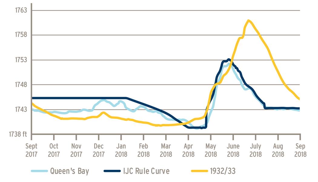
Kootenay Lake elevations in a typical year
Related links
- 1938 International Joint Commission order on Kootenay Lake
- International Kootenay Lake Board of Control
- BC River Forecast Center
- BC Hydro Hydrometeorological Data
- Environment Canada Water Office
- US: Northwest River Forecast Center
- Libby Dam
- Libby Dam Flow Information
- Kootenai River at Bonner’s Ferry Flow Information